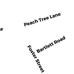
4 BARTLETT RD
Owner Information
DRINKWATER MICHELLE
4 BARTLETT RD
DANVERS, MA 01923


Property Details
4 BARTLETT RD is classified as a Single Family Residential (Ranch).
The primary structure on this property was built in 1955. There are 958ft2 of built area within this property. There is 958ft2 of residential/living space within this property. This property is listed as having 4 rooms.
4 BARTLETT RD is valued at $375,600. The land is valued at $263,100 and the structures are valued at $112,500.
This property is in Zone R2. Confirm with local Zoning Board authorities to ensure there are no overlays or other easements on this property.
The most recent deed for 4 BARTLETT RD is recorded at the local registrar in Book 34937, Page 411. 4 BARTLETT RD was last sold on Friday, May 20, 2016 for $335,000.
Assessment data from fiscal year 2022.
Flood Data
According to the FEMA National Flood Hazard Layer, this property does not appear to be in a flood zone. It may also be in an area not yet reviewed. Nonetheless, confirm this information prior to taking any action.
To view the flood hazards around this property, create a FEMA "Firmette" Map of the area around 4 BARTLETT RD.
Broadband Internet Providers
| Provider | Type | Bandwidth (mbps) | |
|---|---|---|---|
| GCI Communication Corp. | Satellite | 0 | 0 |
| HughesNet | Satellite | 25 | 3 |
| VSAT Systems, LLC. | Satellite | 2 | 1 |
| Viasat Inc | Satellite | 100 | 3 |
| Verizon New England Inc. | Fiber | 940 | 880 |
| Comcast | Cable | 1000 | 35 |
Broadband service provider data from December 2020.
Adjacent Properties
- 6 BARTLETT RD
Single Family Residential owned by LEE ALINA D TRUSTEE - 20 FOSTER ST
Single Family Residential owned by DALTON EDWARD T - 18 FOSTER ST
Single Family Residential owned by LeDUC DEREK - 7 PEACH TREE LANE
Single Family Residential owned by HOPKINS KAREN A. TRUSTEE - 5 PEACH TREE LANE
Single Family Residential owned by TIBBETTS JOHN W